
The staff of the TSU laboratory Bio-Geo-Clim is creating an image bank that will include all the main soil types represented in the latitudinal profile of Western Siberia, from steppes to tundra. A new information base will help researchers reconstruct past ecosystem changes in the macroregion and predict future soil transformations.
- The project will evaluate and systematize a variety of morphons — elements of the soil structure that are indicators of soil processes - says Sergey Loyko, project manager, a senior researcher at Bio-Geo-Clim. - Digital photographic equipment and microscopy have significantly improved morphological analysis. Thanks to the digitalizing, in the last 5–10 years, morphology has gone from primitive eyeballing to exact divisions of soil science. Finally, the morphological appearance of soils is conveyed not by words, but by accurate images with high resolution and realistic colors, which helps to apply statistical methods of data analysis to soils.
The fundamental knowledge gained during the new project will help build models of the dynamics of soil changes - to predict how soil fertility will change in a given territory, or which areas will be at risk of degradation.
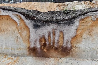
Soil formation is a process of joint influence of climate, topography, living organisms, rocks, and time. Traces of this activity are stored in soils and are visible on sections and fractures. Digital soil counterparts collected in an image bank and supported by laboratory studies of the age and composition of morphons will help us to reconstruct the picture of changes that occurred in Western Siberia in the Holocene (the last 11,000 years) and at the end of the Late Pleistocene (11,000-24,000 years ago). For example, you can see the fires of the past, their frequency, and understand whether there was a forest, river, pasture, or arable land in a given area. Characteristic soil changes will help to understand how the climate was at the stage of its formation and how the environment changed. Using these approaches, researchers are trying to understand whether the climate alone has been responsible for environmental variability in recent millennia.
In the process of creating the new information base, researchers will test several scientific hypotheses, for example, that the smallest soil morphological elements are the last carriers of memory of past situations.
- Ecosystems succeed each other, so over time, the “traces” of their predecessors are erased, - says Sergey Loyko. - In the beginning, there is one ecosystem, for example, a meadow steppe with a dark humus horizon. Then a forest comes in its place. The humus horizon begins to degrade. At first, the traces of the meadow steppe are still well preserved, but after millennia, the traces of it are erased, and at some point, only small morphons remain, often the size of a pea. These are the last storage media, sometimes there is simply nothing more about the extinct ecosystem. Our task is to learn to recover information based on even these small pieces.
As Sergey Loyko notes, the trends identified are important not only for understanding the past but also for predicting the future development of soils. Their new states also appear from the “birth” of new morphons. For example, the beginning of the swamping process can be judged by the appearance of a peat horizon, and the loss of soil fertility will begin with the disappearance of through-pores.
The new project has the website http://photosoil.tsu.ru/, which hosts some database elements that are now available for free viewing.